Robert Louis Stevenson State Park
A Beautiful Hike and Breathtaking Summit Views
Review by Stefani Hays
‘This park boasts a five-mile hike to the top of Mt. St. Helena, from which you can see much of the San Francisco Bay Area, and on a clear day, all the way to the top of Mt. Shasta.’

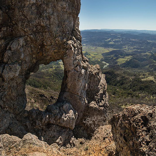
View of Napa Valley from the Promontory
 California boasts many state parks, and most with histories that are little known to the average visitor. Robert Louis Stevenson State Park is one such locale, with a background and founding as storied as its namesake.
The park is named after Robert Louis Stevenson, the author of Treasure Island and Kidnapped. In 1880, Stevenson and his wife, Fanny Vandergrift Osbourne, spent their honeymoon in a cabin at an old, out-of-service silver mine on the mountain. While the cabin no longer exists, it is identified by a plaque on the trail to the summit. Stevenson’s book, Silverado Squatters, contains stories he wrote about his experiences during his time spent in the area. The park is located off State Route 29 between Calistoga and Middletown, and is registered as State Historical Landmark #710. The park covers areas in Sonoma, Lake and Napa counties.
Before describing more of the physical characteristics and activities one can engage in when visiting the park, I feel it’s important to mention one of the key co-founders of this park and his role in ensuring its existence today. Putnam Livermore, a lawyer and managing partner at Chickering and Gregory, was a well-known California preservationist and the co-founder for The Trust for Public Land. He played a key role in the formation of eleven of the California State Parks, Wildlife Areas or Natural Reserves. While Livermore was serving in the Pacific Theater of World War II, his mother, Caroline, a Marin County conservationist, was fighting for parks, open space and planning. Together they believed in parks as patriotism. Putnam’s post-war work as a lawyer landed him in circumstances which allowed him to fight for this form of patriotism.
The Robert Louis Stevenson State Park was close to Livemore’s heart, as his family gave the first 1000 acres to create the park area. The family legend is his aunt, Edith Livermore, asked playwright and novelist Somerset Maugham, who was always invited to her salons, to help due to his admiration for Robert Louis Stevenson. When Maugham refused, enterprising Edith auctioned off the refusal letter to raise money for the park. Once the older members of the family were gone, Putnam Livermore remained the most involved with this park. In particular, he helped with the creation of the 10.6 mile out and back St. Helena Trail.
Thanks to Livermore’s involvement, the Robert Louis Stevenson State Park is now a great to place to visit both for it’s beautiful hike and breathtaking views from the summit. My family decided to visit on a day trip to the Napa Valley/Calistoga area. Depending on the time of year you visit, it is advisable to consider the weather, as it can get quite warm during the summer for this decently long hike. The area features rough terrain, with evergreen forests in the canyons on north-facing slopes and chaparral on the south-facing slopes. There is a five-mile hike to the top of Mt. St. Helena, from which you can see much of the San Francisco Bay Area, and on a clear day, all the way to the top of Mt. Shasta. Keep in mind that dogs are not allowed at this park or on the hiking trail. As this is a longer hike round trip, I would not recommend it for anyone not fit for the challenge, including the elderly and small children.
Be sure to come prepared for a long hike, but well worth the view once you reach the top. It is a round trip hike with the same path up and down (not a loop), which takes about 4 hours total. The biggest piece of advice I can give to anyone taking this hike is to stay right! The signs are not great and if you go to the left you may end up in directions you didn’t want to be and without the views you hoped to see. If you stay to the right when given the choice you should be in good shape to get to the summit with incredible views! It is a very scenic hike and in the spring you may even be lucky enough to see some prolific wildflowers.
It is important to note that after the recent Tubbs wildfire in 2017, there are some areas along the hike with views of burned vegetation, but the view from the top is still amazing and not to be missed!